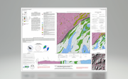

This multi-colored map of the Burnsville 7.5-minute quadrangle includes a description of map units, whole rock ICP analysis of selected samples, a correlation diagram, Schmidt equal area stereonet data, a traverse map, a tectonic map and one cross section.
By Mark Adams, Bart Cattanach, Joshua Benton, Brennan Trantham and Ashley Lynn. Approximate map scale - 1:24,000. Map size - 48" x 36". 2024.
|


