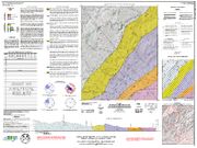

This multi-colored map of the Old Fort 7.5-minute quadrangle includes a description of map units, whole rock ICP analysis of selected samples, Schmidt equal area stereonet data, a traverse map and one cross section. Contains portions of Yancey and McDowell counties.
By Bart L. Cattanach, G. Nicholas Bozdog, Sierra J. Isard and Richard M. Wooten. Approximate map scale 1:24,000. Approximate size of map - 48" x 36". 2019.
|


