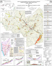
This multi-colored map of Gorges State Park includes a description of map units; soil sample data for selected sites; a map, description and cross sections of the Toxaway River Slide; tree ring analysis data; and two cross sections.
By Richard M. Wooten, Carl E. Merschat, and Mark W. Carter, 2003. Scale 1:12,000. Map size approximately 36"x42".
|