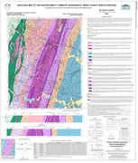
The geologic map for the Raleigh West quadrangle has been created as a general-purpose map that is applicable to land-related investigations in the earth, environmental and biological sciences. Includes Schmidt net equal-area plots, whole-rock major and trace element compositions, two cross sections and rock unit descriptions. By David E. Blake, 2008. Scale - 1:24,000. Approximate size is 37"x42".
|


