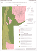

The geologic map for the western part of the Rocky Mount 100k quadrangle has been created as a general-purpose map that is applicable to land-related investigations in the earth, environmental and biological sciences. Includes rock unit descriptions. Covers the Nashville, Rocky Mount, Wilson and Winstead Crossroads quadrangles, as well as the northern portion of the Elm City quadrangle.
By Norman K. Gay. 2004. Scale - 1:50,000. Approximate size is 36"x42".
|


